
Xiropigado Chronology
A small description of our Village history.
The village Xiropigado, the province of Arkadia, is located at the northeastern edge of the province and is the last part of it. It is stretched out in different parts of the northeastern side of the mountain Zavitsa (976 m height), starting from the position "Lileika" to the position "Ai-Giorgis" of Kiveri and ending up to the position "Sotira". It is 10 km from Astros, 18 km from Argos and 50 km from Tripoli .
Xiropigado (a dry well in Greek) has its name from a dry well in the area "Hania", which did not have water, because it was not found water when dug it or because it was (summer usually) dry.


The main geographic elements of the area where the village was developed are the mountain Zavitsa and from the sea the Argolic Gulf. This territorial combination of mountain and sea creates a climate that is extremely healthy, suitable for holiday. The main characteristics of the sea of Xiropigado are the depth and purity of the sand of its waters.
The most important and rare natural attraction of the village is "Anavalos Xiropigado" (Lileko eye or Lilis eye), which is the flowing of fresh water in the sea at Lileika. At a distance of 150 meters from the coast and 80 meters below the sea level it swells on the surface.


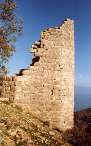
There are no written testimonies about the presence of people in Xiropigado during the ancient and medieval-Byzantine times. However, it is not excluded that some people lived at that time in some parts of the village, as some findings show at the "Xalasmata","Klima", "Sotira", "Filakio Xiropigado" (in Lileika), "Filakio Xilopirgou" or "Paliopyrgos" (west of Alafitsa) and "Voukolopirgos tower" in Tsiouleika. It is not certain that from the coastal road of the village, going from Argolida to Astros, Pausanias passed (in the 2nd century AD). some scholars argue that he crossed the mountain road of Zabitsa, from Potamia, Elafitsa,Tsorovo, Doliana, Astros.
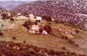
The immediate ancestors of the current Xiropigado villagers were from Vervena village, who began to descend in this area rather in the last years of the Ottoman occupation, in the foothills of Zavitsa in neighborhoods in places that served mainly the livestock occupations of the inhabitants. However, since the transition to Vervena during the summer period was difficult by foot and it lasted for a whole day, it stopped slowly from the end of the 19th century and until the summer stay was Zavitsa mountain as neighborhoods, since there was the main source of water in the village (Sotira). However, after the opening of the Astros-Kiveri road (1953) the permanent residence of the villagers in the central coastal settlement (xania) . In parallel with the houses of the local residents, in the last years they were built holiday houses and apartments.


Administratively the Xiropigado until 1950 belonged to the community of Verbena. From 1950 to 1998 he was his own community. From 1-1-1999, it was annexed to the Municipality of North Kynouria, based in Astros, and was named Municipal District (DD) Xiropigadou.
The number of inhabitants of the village during the census (1981) was 170, while during the last (2001) 420. The inhabitants of the village were formerly livestock and agricultural (cereals and olives). Today, these occupations have been limited and residents are more busy with tourism businesses and technical professions.


Xipopigado until 1982 was part of the Verbena Parish of the Metropolis of Mantineia and Kynouria, and since 1983 it has been a separate parish with its own priest. The churches of the village Evangelismos (Vangelistra), Agia Marina (new church in the central settlement), Sotira, Prophet Elias (at the top of Zavitsa), Agios Panteleimon, Agios Constantine.


Today, Xiropigado is a beautiful tourist resort with crystal clear sea, mild climate, modern holiday homes, essential and good shops for buying food and fantastic coastal taverns.